We have all we need for everyone to live well.

Friday, June 10, 2016

Mount Defiance via Pratt Lake Trail and Thompson Lake Trail

Circumstances allowed me another day out this week, and Wednesday I set myself a good challenge. The most common approach to Mt Defiance is via the Ira Spring Trail to Mason Lake, 11 miles roundtrip and 3900 ft cumulative climbing. What I had in mind was a 14 mi jaunt among the Pratt Basin lakes and then up Defiance, for a cumulative 4750 ft of climbing. I had the additional constraint of a late afternoon appointment in the city, so there could be no dawdling.

I returned to the Pratt Lake / Granite Mtn Lookout Trailhead where I began Monday's hike (lower right on the topo map, hard by the highway intersection), 1900 ft elevation, at 5:30 a.m. The trail ascends steadily on a remarkable miles-long traverse through deep forest filled at this hour with the dawn chorus of birdsong, across numerous falling streams. And much of the time crossing a slope so steep that to stumble off would be a tumble. But it's a broad, well-engineered trail and one rolls along at a pretty good pace, uphill or down.


When an opening finally appears in the forest, this is the view: Ollalie Lake and across the South Fork Snoqualmie River valley, and Rainier melding with the clouds.


The trail rounds the lake and splits at the Pratt Saddle. Down to the right is Pratt Lake, and forward is the Thompson Lake Trail which sidehills across Pratt Mtn and into the basin.


This trail is in good shape but is significantly less traveled. There are excellent views of Lake Talapus, and waterfalls on the back of Bandera Mtn. From elevation 4560 the trail descends a steep 300 ft that I knew would be a lot harder coming back up. This was also the farthest I had come before on this trail so I wasn't completely sure of my way. A look at the map shows it could be a little confusing. I began to encounter vagrant tatters of the snowpack that a month ago completely filled the basin, and got my first view of Mt Defiance. It still seemed far away.


Down in the Pratt Basin I kept right toward Rainbow Lake and followed a wet and at times muddy and slushy path down to the lake. The last of the snow was melting and the trail was often a running stream with a thin bridge of snow over it, so I had to keep to the side or break through, which I did anyway.


Rainbow Lake.


 And a little farther to this small shallow unnamed lake and sunshine.


From that same lake, the back of Bandera Mtn and Little Bandera. These look like good camping spots later in the year but on this day the ground was spongy.


After climbing up and over a ridge I was in the Mason Lake basin and at this major junction returned to familiar territory. Now the final push, 1300 ft of steep to the summit, with long sections of roots and running water down the trail. Dense forest defies any wide views until it gives way all at once to a spectacular meadow.


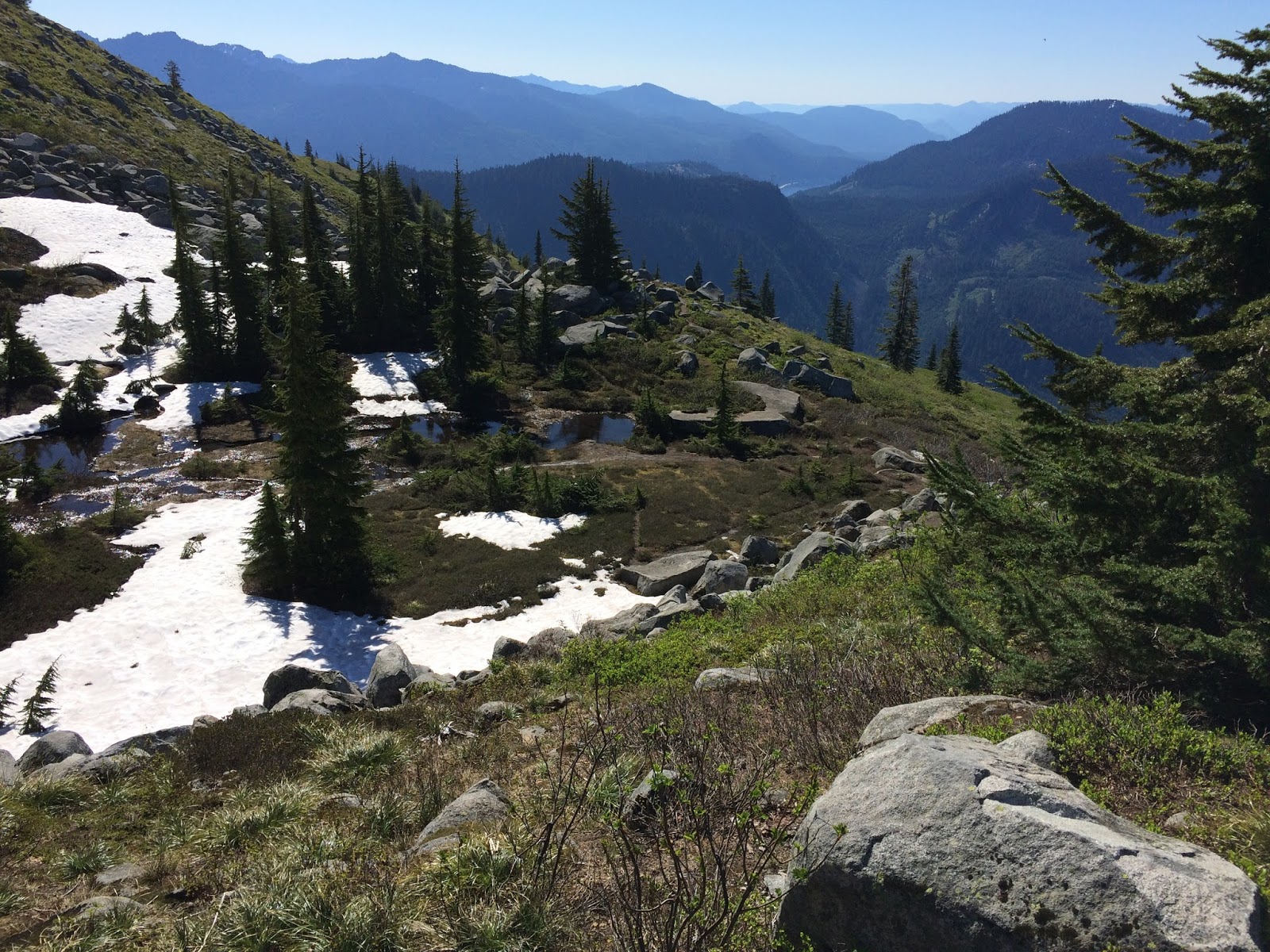
And this view to the south.


Forward, one of my favorite little sections of trail anywhere. Hike across as far as the eye can see, then turn sharply right and climb straight up to the top.


And to 5584 ft up on the summit, at 10:00. Again, I had it all to myself. Again, there was barely a breeze. I took a little breather, made hot chocolate, and sighed again and again at the beauty and magnificence of the surroundings.


Looking east to Lake Kulla Kulla, then Pratt Mtn, then Granite. I could make out the fire lookout cabin. Lakes Blazer, Rainbow, Island, and Mason are also visible in this photo.


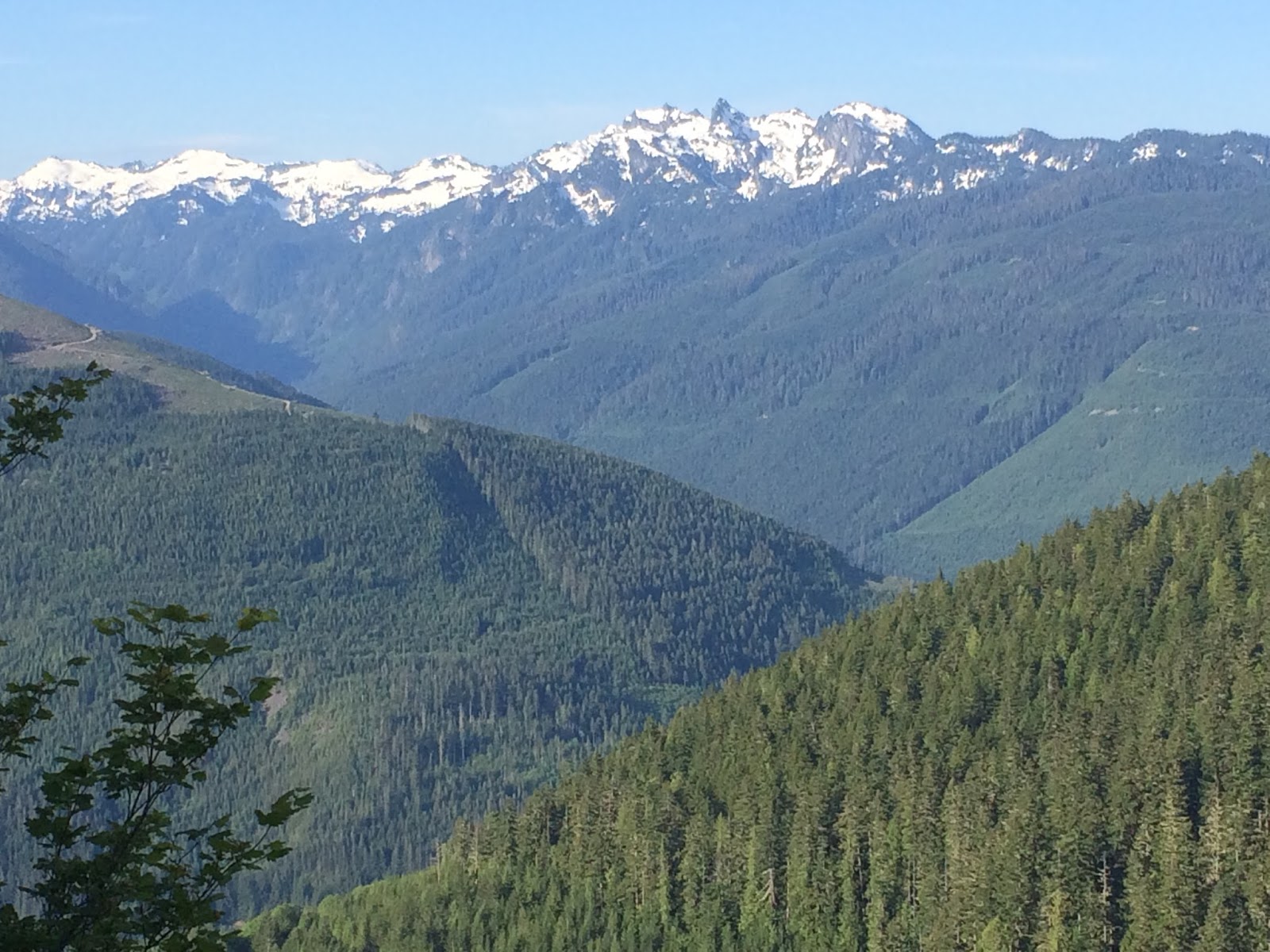
The view north. Volcanoes Baker and Glacier are out there on the horizon.


But I was only half-way, so after 20 minutes I started back down. I stopped at the unnamed lake to pump water and not again until I'd climbed out of Pratt Basin to encounter this view south, out above Lake Talapus. From here at 4560 ft it was a steady downhill to 1900 ft and my beginning. I was mighty glad it was all downhill.


And here is some video I collected along the way. Remember HD & fullscreen!


Tuesday, June 7, 2016

Granite Mountain (Snoqualmie): sapphire skies, sunbathing marmots

Back to Snoqualmie Pass for this week's hike, out I-90 to Exit 47 and the Pratt Lake / Granite Mtn Lookout Trailhead. Granite Mtn gets a lot of use as a "training" hike; at four miles one-way with 3800 feet of climbing to the fire lookout cabin at 5629 ft, it's one of the steepest sustained hikes in the area.

It's also a hot hike at almost any time of year if the sun is shining. The entire route is up and across the south face of the mountain and with much exposure crosses boulder fields, meadow expanses, and snowy basins. Yesterday the temperature was in the 70s and the nearly solstice-high sun blazed from cloudless skies. Going up wasn't uncomfortable but coming down I eventually craved the shade even of single trees until I got back in to the lower deep forest.

I was first up the trail at 6:30 a.m. and didn't encounter another person until I'd begun my descent, eventually passing 20 before returning to the trailhead at 1:00 p.m.


The trail switchbacks up alongside this avalanche chute, looking 2000 ft up along the enormous concave southern slope of the mountain.


Looking downhill and south across the South Fork Snoqualmie River valley.


Looking along the final long westerly traverse to get up to the tarns and tumbled boulders near the summit.


At the top of that traverse the trail dips behind the mountain's southeast ridge where, more protected, there was still a lot of snow. A real alpine environment up here.


The view east across Snoqualmie Pass, Keechelus Lake and beyond.


Still some ways to go at this point, and now it was mostly in the snow, which was rapidly melting and increasingly slippery slushy as the sun rose higher.


Marmots! Well, there's one on that round boulder center frame. The highlights of today's hike were observing this marmot for a while on my way up, then a whole clan of a half-dozen on my way down. Big creatures with long golden and gray fur, gliding sinuously across the snow fields and rock faces and boulders. They sunned themselves, nibbled at tender greens, greeted their fellows, sometimes standing face to face on hind legs and pawing at one another in what seemed very friendly fashion. They whistled, pure and clear and so loudly I could hear echoes. I think these were hoary marmots (2-3 ft long with tail and 10-25 lbs, according to wikipedia).


A dramatic difference between the south and north sides of the mountain's eastern ridge, summer and winter.
 
 
From that point I took the "snow" route north but was stymied at a vertical section that leads to the summit scramble. Just too steep in the slippery conditions. This is the view north a little farther from that point, across Denny Lake and deep into the Alpine Lakes Wilderness. I soon realized I was standing only on snow here, having walked beyond the edge of a cliff. It wasn't a cornice but still might have slid. I backed away slowly.


Looking south at the way I'd come, I contemplated traversing the snow upward to intersect the boulder route on the spine of the eastern ridge, and making my way to the lookout from there.


Yes, I did wear a hat. And sunscreen. But it was a short sleeves and short pants day.


I began and abandoned a couple attempts to intersect the boulder route after I began to post-hole through the snow with no idea what voids might exist underneath. So I found my ascending tracks and followed them back to the dry trail, from where I could make the official start up the boulder route. The pinkish brown marks on the boulders where the lichen is worn away were about the only indication of "trail" from this point.


I spent about 20 minutes working my way up then called it quits, maybe 200 ft below and a quarter mile from the summit. From here at about 5400 ft this view of Mt. Rainier to the south. This shows the entire extent of the climb; the trailhead is down at the interstate.


Having descended some from my high point, looking back at the summit. Out there somewhere is Seattle.


And on the other side.


A final look back up. That's a magnificent waterfall, and this is about as close a view as one can get, so thickly overgrown is the avalanche chute.


And here's a bit of video from the hike: a panorama from the boulder ridge, and a pleasant little waterfall. As always, use HD and full screen!


Beckler Peak in the clear air

Last Wednesday I drove a little farther than usual for my day hikes, up Highway 2 to Skykomish, much of the way up Stevens Pass. Nine miles off the pavement is the Jennifer Dunn Trailhead, and then it's 2260 ft up and 3.7 mi forward to the summit, first along converted logging road with numerous little creek crossings, up to an old logging platform with wide views to the south and west. The trail enters a parkland of older growth and I climbed eventually into snow that gave way to the final ascent through rotted granite outcroppings and finally the bare rock summit. The cool, still air was particularly clear, allowing especially detailed views along the horizon.


Occasional views to the south as I climbed began to reveal the snowy larger mountains in the distant Alpine Lakes Wilderness where I usually hike.


I walked a quarter-mile or so across a snowfield near the summit, a dirty and hard-packed remnant of winter before the shade gives way to rocky and sunny ground.


The last of the snow.


From the summit at 5028 ft, this view to the north of the Wild Sky Wilderness and beyond to volcano Mt. Baker.


There was so little breeze that I had my breakfast upon the true summit, boiling water for hot chocolate and gazing around and around.


The monochromatic skies were filled with lenticular clouds, here to the east over Stevens Pass.


This was my view to the west, Mt. Index prominent in the background on the right.


Switchback through the parkland below the snow.


And another switchback.


Lots of little streams, chirruping waters.


Here's a collection of video from this hike. Be sure to use full-screen and HD!