A very different hike on Thursday than last week's Davis Peak, as the
topo shows. Up to Snoqualmie Pass and south beyond the ski slopes to
the Cold Creek trailhead. Twin Lakes are at the bottom of a bowl that I
looped around counterclockwise, with side trips to summit Mt. Catherine
then Silver Peak, and including a few miles of the Pacific Crest Trail.
About 12 miles roundtrip and 3900 feet of climbing altogether. Lots of
storm-downed trees on the Mt. Catherine trail which is
little-maintained, some 4 and 5 feet in diameter that were a
considerable challenge to get past. This hike has a lot of everything:
old forest, lakes and streams and waterfalls, enormous views, tortured
mountain landscapes, deep shade and bright sunlight. Highly recommended.
The wind really blows up here sometimes.
Upon
Mt. Catherine's summit, formerly the site of an aircraft navigation
beacon for Snoqualmie Pass over the Cascades. The guy cables and front
panel of an equipment box are about all that remain.
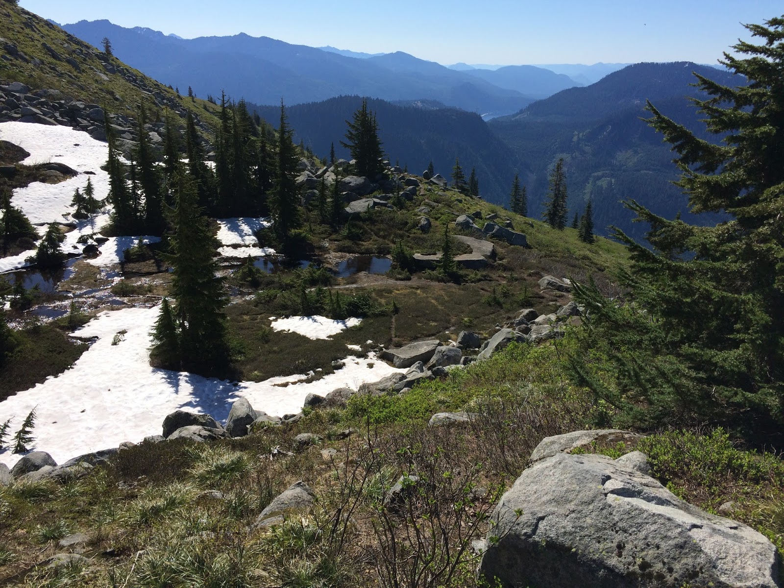
From
Mt. Catherine, looking across the Cold Creek basin around which I
walked. My next destination was Silver Peak, on the right. Abiel is the
next peak, then Tinkham, with Rainier in the background.
Lake Keechelus and off into eastern Washington.
The Pacific Crest Trail at Windy Pass.
In Ollalie Meadow, one of my favorite alpine lakes.
After side-hilling through the forest beneath Silver on the PCT, a first glimpse of the southern ridge I'll eventually climb.
From the Tinkham/Abiel/Silver saddle, looking north at Silver.
Felsenmeer. This is really steep, and a lot of the stones move at least a little when trod upon.
Over Snoqualmie Pass yesterday onto the dry eastern slopes of the
Cascades, to Cle Elum, Roslyn, Salmon La Sac, and after a couple hours
of driving arrived at the Davis Peak trailhead at 7:00. This hike is
about 11 miles roundtrip and 4000 feet of climbing up to 6490 ft, about a
thousand feet higher than I'd climbed yet this season. As the topo map
shows, this is a trail of relentless switchbacks heading due north up
the mountain. Deep forest eventually gives way to an old burn
zone and flower-filled alpine meadows and finally to naked rock. The
named summit is the site of an old fire lookout of which nothing remains
but some desultory bits of lumber and ironmongery, and a pile of stone
remade as a hiker's shelter. The true summit is another half-mile along a
narrow ridge. There is very little real estate at the top, but the
views! Mountains, mountains, mountains.
The trail first descends to Paris Creek then plunges into the forest and shortly after the switchbacks begin.
The trail begins at about the elevation of Lake Cle Elum and ascends this far before a view opens.
A false summit. The trail swings around to the right across a bowl.
The ruined tower.
On to the true summit.
Up on top, barely enough room to turn around. Lake Cle Elum again, and volcano Rainier in the center.
A shallow tarn directly below, then Opal Lake, and Terrence Lake in the distance.
From the true summit looking back toward the lookout site at the end of the ridge.
And down again.
The Cascades' ridgeline, holding back the marine layer on the west side.
Back to Snoqualmie Pass for this week's hike, out I-90 to Exit 47 and the Pratt Lake / Granite Mtn Lookout Trailhead. Granite Mtn gets a lot of use as a "training" hike; at four miles one-way with 3800 feet of climbing to the fire lookout cabin at 5629 ft, it's one of the steepest sustained hikes in the area.
It's also a hot hike at almost any time of year if the sun is shining. The entire route is up and across the south face of the mountain and with much exposure crosses boulder fields, meadow expanses, and snowy basins. Yesterday the temperature was in the 70s and the nearly solstice-high sun blazed from cloudless skies. Going up wasn't uncomfortable but coming down I eventually craved the shade even of single trees until I got back in to the lower deep forest.
I was first up the trail at 6:30 a.m. and didn't encounter another person until I'd begun my descent, eventually passing 20 before returning to the trailhead at 1:00 p.m.
The trail switchbacks up alongside this avalanche chute, looking 2000 ft up along the enormous concave southern slope of the mountain.
Looking downhill and south across the South Fork Snoqualmie River valley.
Looking along the final long westerly traverse to get up to the tarns and tumbled boulders near the summit.
At the top of that traverse the trail dips behind the mountain's southeast ridge where, more protected, there was still a lot of snow. A real alpine environment up here.
The view east across Snoqualmie Pass, Keechelus Lake and beyond.
Still some ways to go at this point, and now it was mostly in the snow, which was rapidly melting and increasingly slippery slushy as the sun rose higher.
Marmots! Well, there's one on that round boulder center frame. The
highlights of today's hike were observing this marmot for a
while on my way up, then a whole clan of a half-dozen on my way down.
Big creatures with long golden and gray fur, gliding sinuously across the
snow fields and rock faces and boulders. They sunned themselves, nibbled
at tender greens, greeted their fellows, sometimes standing face to
face on hind legs and pawing at one another in what seemed very friendly
fashion. They whistled, pure and clear and so loudly I could hear echoes. I think these were hoary marmots (2-3 ft long with tail and 10-25 lbs, according to wikipedia).
A dramatic difference between the south and north sides of the mountain's eastern ridge, summer and winter.
From that point I took the "snow" route north but was stymied at a vertical section that leads to the summit scramble. Just too steep in the slippery conditions. This is the view north a little farther from that point, across Denny Lake and deep into the Alpine Lakes Wilderness. I soon realized I was standing only on snow here, having walked beyond the edge of a cliff. It wasn't a cornice but still might have slid. I backed away slowly.
Looking south at the way I'd come, I contemplated traversing the snow upward to intersect the boulder route on the spine of the eastern ridge, and making my way to the lookout from there.
Yes, I did wear a hat. And sunscreen. But it was a short sleeves and short pants day.
I began and abandoned a couple attempts to intersect the boulder route after I began to post-hole through the snow with no idea what voids might exist underneath. So I found my ascending tracks and followed them back to the dry trail, from where I could make the official start up the boulder route. The pinkish brown marks on the boulders where the lichen is worn away were about the only indication of "trail" from this point.
I spent about 20 minutes working my way up then called it quits, maybe 200 ft below and a quarter mile from the summit. From here at about 5400 ft this view of Mt. Rainier to the south. This shows the entire extent of the climb; the trailhead is down at the interstate.
Having descended some from my high point, looking back at the summit. Out there somewhere is Seattle.
And on the other side.
A final look back up. That's a magnificent waterfall, and this is about as close a view as one can get, so thickly overgrown is the avalanche chute.
And here's a bit of video from the hike: a panorama from the boulder ridge, and a pleasant little waterfall. As always, use HD and full screen!